Longmont Weather Report — November 27, 2025 to December 4, 2025
Expect an active week across the Intermountain West. A series of systems will drive periods of snow and rain from Montana and Wyoming down through Colorado, with a strong cold front and model uncertainty making exact totals hard to pin down. This summary highlights the key trends, where the heaviest snow and rain are likely, what the temperature outlook looks like, and how drought and records might play into the next few weeks.
Table of Contents
- Weekly snapshot: what to expect
- Snowfall highlights and likely corridors
- Temperature story: a sharp dip then variability
- Model differences and uncertainty
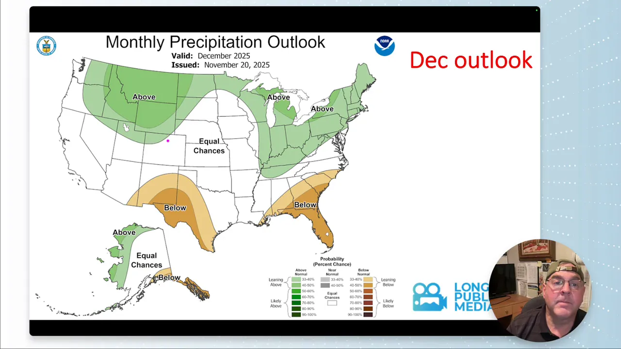
- Precipitation and drought implications
- Daily pattern overview
- Will Longmont see heavy snow this week?
- How cold will it get and when?
- Are record temperatures or snowfall likely?
- How should I prepare for travel and outdoor plans?
- Final notes
Weekly snapshot: what to expect
Overall pattern: Multiple storm impulses will move southeast from the Pacific into the northern Rockies and Great Basin. Some systems will deliver widespread precipitation while one strong cold front could bring unusually low temperatures for early December. Several model runs differ on placement and intensity, so watch forecasts closely if you have travel plans.
Snow vs rain: Higher elevations through Montana, Wyoming, and the Rockies will pick up the brunt of the snow. The Front Range and Palmer Divide near Denver can expect measurable snow at times, with localized heavier amounts where dynamics and upslope flow align. Lower elevations may see mixed precipitation or rain depending on timing and temperatures.
Snowfall highlights and likely corridors
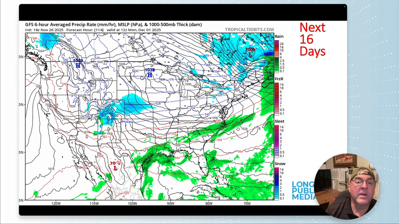
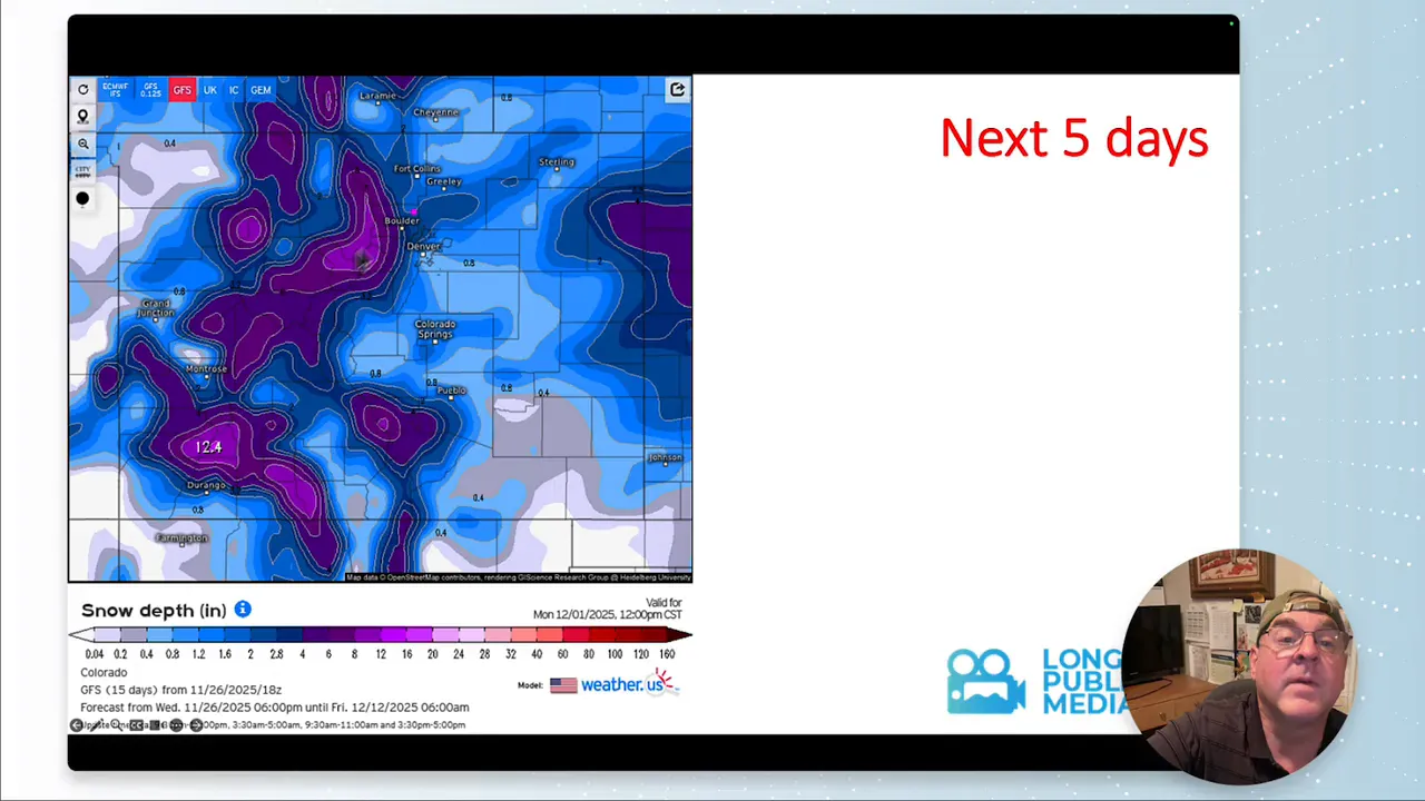
From Friday into Saturday, the most significant snow will occur across Montana into Wyoming, then spread into Colorado. The heaviest corridors tend to follow the higher terrain and the Palmer Divide and the west-facing slopes of the Front Range.
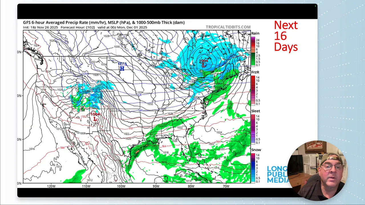
Expect locally impressive totals where mesoscale enhancements set up over favored upslope areas. Early indications show some locations could receive a few inches to one-plus feet at higher elevations; valley totals will vary strongly with storm track and temperature.
Areas to watch
- Montana and Wyoming: Primary snow corridor for the Friday–Saturday system.
- Colorado Rockies and Palmer Divide: Significant mountain snow and periods of accumulation along the Front Range slopes.
- Arizona and southern California: Additional moisture streams may boost rain totals through the week, especially in Arizona.
Temperature story: a sharp dip then variability
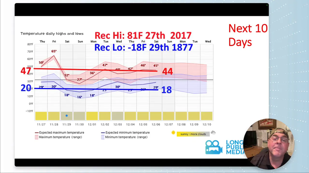
A strong cold front will produce well below-normal temperatures when it arrives. Surface temperatures could drop rapidly, and wind chills will make it feel even colder. Some model ensembles are showing a pronounced cold spike that may set new low records in isolated places for this time of year.
Following the initial cold shot, the outlook moves toward near-normal values, then backs toward a warmer-than-average stretch by the second week of December. That push toward above-normal warmth later could be brief but notable.
Model differences and uncertainty
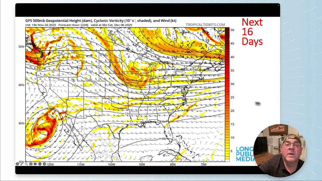
Not all models agree. One potential cold front and snowfall scenario shows up in some guidance but not in others. That means:
- Timing and amounts remain uncertain for specific valleys and lower elevations.
- Higher-elevation snow forecasts are more reliable, but lowland totals can shift quickly.
- Watch for last-minute adjustments to snowfall maps as model runs converge.
When models disagree, small shifts in storm track can flip precipitation type from rain to snow for many communities. Prepare for mixed precipitation in transitional elevations.
Precipitation and drought implications
Extra precipitation this week will help drought conditions in some regions, especially where the heaviest precipitation falls. Areas that typically need mountain snow to support long-term water supply will benefit most if the storms deliver consistent mountain accumulations.
However, a quick return to normal or a brief warm-up after the cold shot could limit how much water actually accumulates as snow versus melting. In short, the week offers relief potential but not a universal fix for drought.
Practical takeaways
- Travel: Expect winter driving conditions in mountain corridors. Plan extra time and keep chains or a winter-rated vehicle ready for high passes.
- Outdoor plans: Mountain recreation will see fresh snow, but low-elevation outdoor activities might face freezing temperatures and mixed precipitation.
- Storm timing: Small shifts in timing can change precipitation type; monitor short-term updates for the most accurate forecasts.
Daily pattern overview
Key periods to watch this week include:
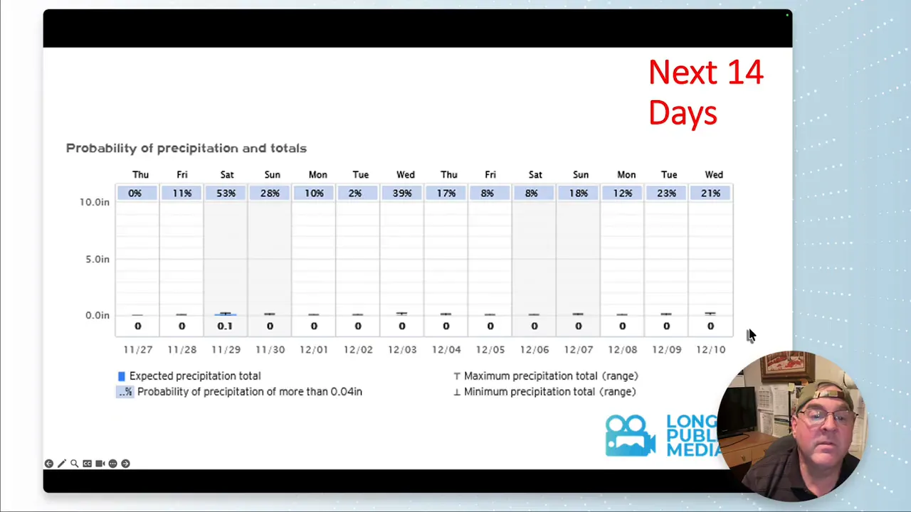
- Late-week system (Friday–Saturday): Primary snowfall for Montana, Wyoming, and the Colorado high country.
- Midweek pulses: Additional moisture streams will periodically enhance rain or snow chances, mainly over mountain areas and into Arizona.
- Late next week: Temperatures trend toward near-normal then a possible warmer spell by the second week of December.
Will Longmont see heavy snow this week?
How cold will it get and when?
Are record temperatures or snowfall likely?
How should I prepare for travel and outdoor plans?
Final notes
The upcoming week will be active and changeable. The combination of a strong cold front, multiple moisture streams, and model differences means staying flexible is the best strategy. Mountain snow will be the headline for many communities, while lower valleys should watch for mixed precipitation and rapid temperature changes.
Key terms to remember: cold front, upslope snow, storm track, model uncertainty, and drought relief potential.
