Longmont Weather Report – November 19, 2025 to November 26, 2025
The week ahead brings a brief pulse of moisture midweek, cooler but not arctic air, and continued concerns about dryness along the I-25 corridor. Expect a cloudy Thursday into Friday with a short-lived storm that mainly benefits the mountains, then a sunny weekend before clouds return next week. Sunrise is at 6:53 a.m. and sunset at 4:39 p.m., with another loss of daylight compared with last week.
Table of Contents
- Quick snapshot
- Why this little storm matters
- Daily look
- Winds and severe weather
- Drought, smoke, and longer-term signals
- Records and notable numbers
- Model confidence and what to watch
- Practical takeaways
- Frequently asked questions
Quick snapshot
- New moon on Wednesday, November 19.
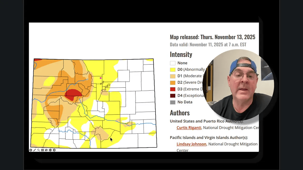
- Drought is persisting in western and northwest Colorado and is expanding along I-25 and south.
- Precipitation for the water year is about 30% of normal, while seasonal mountain precipitation sits near 95% of normal.
- Storm timing: most likely Thursday into Friday for clouds and light precipitation, with a much drier Sunday and a cloudy pattern returning next week.
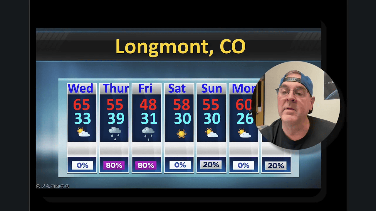
- Temperatures: highs in the 50s early week, cooling into the 40s by the holiday, then moderating back toward the 50s to near 60 next week.

Why this little storm matters
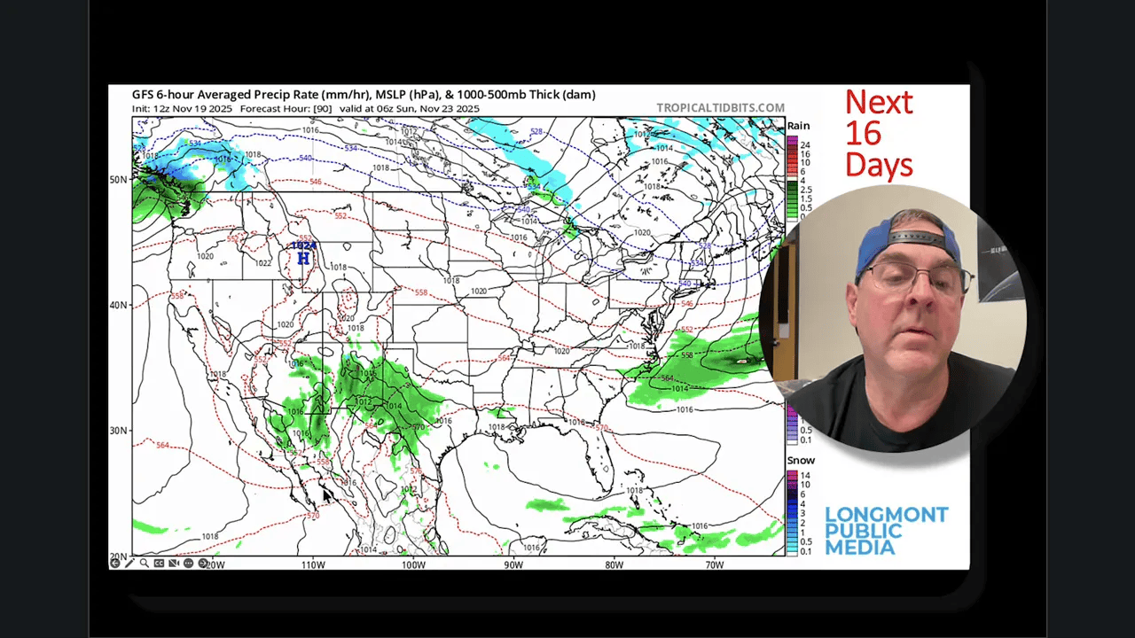
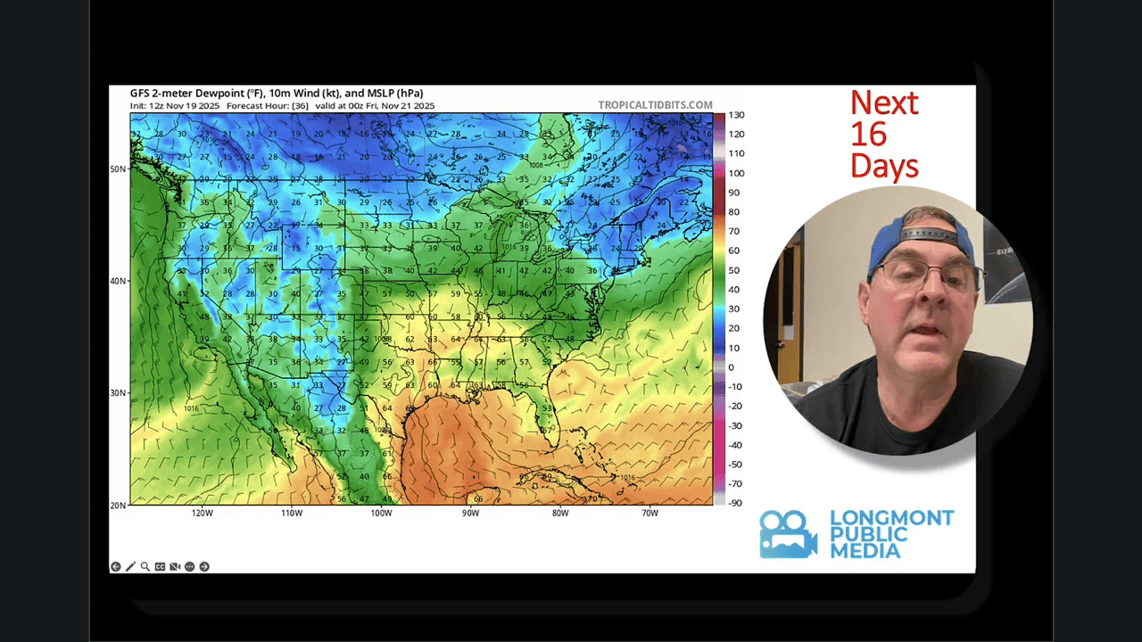
A deep trough dives south far enough to tap moisture and swing a cutoff low toward the Four Corners region. That pattern pulls in above-normal precipitable water for roughly a 36-hour window Thursday into Friday. Most of the measurable precipitation will fall over the western slopes and higher terrain, where a few locations picked up between 0.25 and 1.0 inch of water on recent model runs.
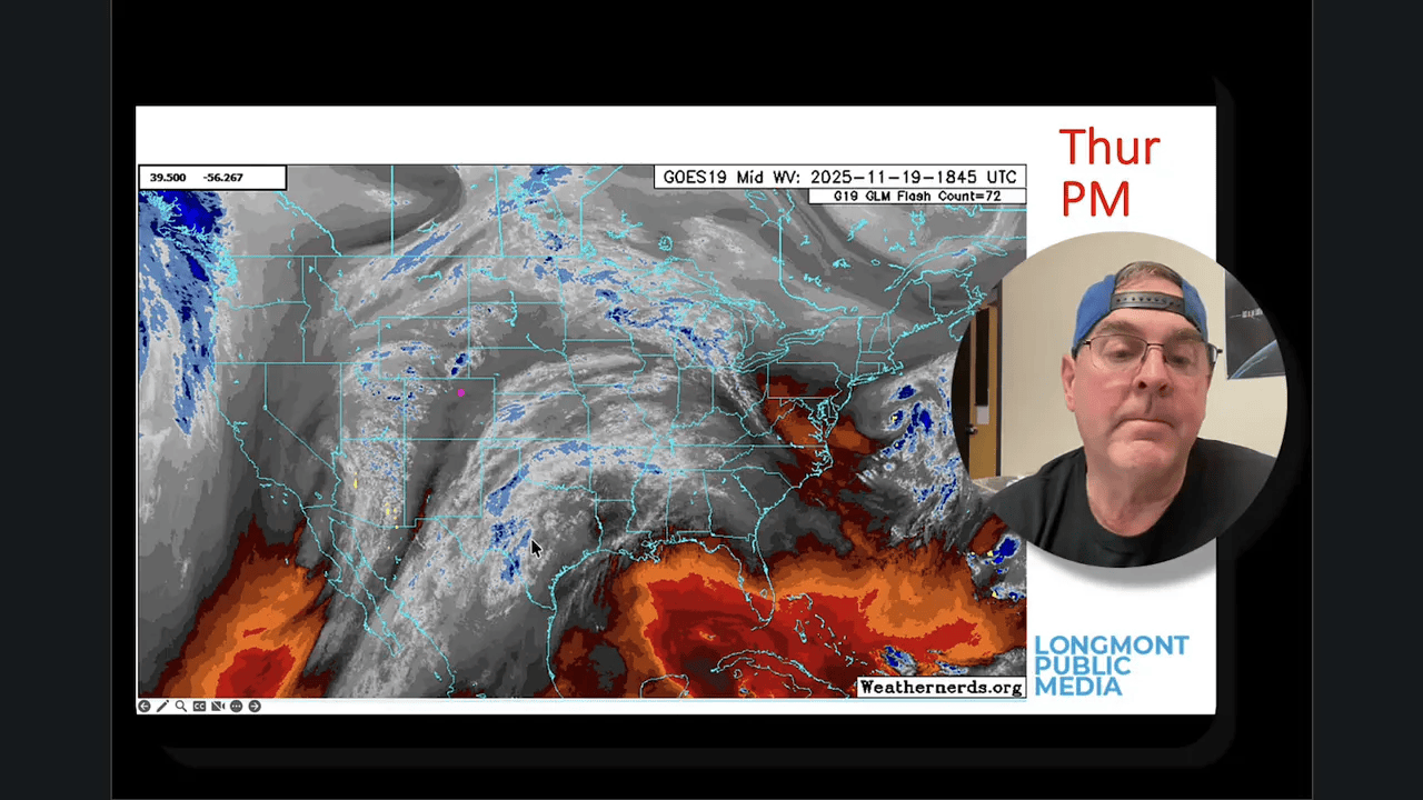
Models disagree on totals for the urban corridor and plains. Many guidance members trim mountain totals to a few tenths of an inch or even a few hundredths near the foothills. One consistent theme is that the moisture surge will be brief. Dew points rising into the 40s are enough to produce decent cloud cover and scattered light rain or snow showers in the high country for a short period.
Daily look
Wednesday (Nov 19)
Dry and mild. Afternoon highs around 65°F in town. Very low thunderstorm risk locally, though a marginal convective risk exists farther south into New Mexico, Texas, and Oklahoma.
Thursday into Friday
Clouds increase Thursday as the trough approaches. Expect the best chance of measurable precipitation Thursday night into Friday morning. Models show a spread in totals; mountain areas will see the lion’s share while I-25 largely remains on the light side.
Temperatures fall into the weekend, with highs sliding from the 50s down into the upper 40s by Friday. Friday morning could feature a few flurries in the air, but accumulation along the plains is unlikely unless models shift.
Weekend and Thanksgiving week
Weekend looks sunny and pleasant after the storm departs. Clouds increase again into next week with above-normal temperature odds overall for the two-week outlook. Nighttime lows trend downward as we approach Thanksgiving, with lows near 19 to 22°F possible around the holiday period in colder pockets.
Winds and severe weather
Winds are generally light through the middle of the week. A brief uptick in wind is possible just before Thanksgiving as flow tries to tighten, but nothing significant is expected locally. Severe weather remains focused to the east over the Mississippi and Ohio Valleys for this period.
Drought, smoke, and longer-term signals
Dry conditions are the dominant background story. The western half of Colorado and the northwest continue to show persistent drought signatures. Conditions along I-25 have moved from drought free into abnormally dry, and the water-year precipitation deficit — roughly 30% of normal — is an early warning for the season.
Smoke from fires is active out west in Oregon and Washington, but it is not currently affecting Colorado. The larger-scale circulation suggests more Pacific systems will pass south of Colorado, with southern California and the Baja region bearing the brunt of stronger moisture injections and possible flooding there.
Records and notable numbers
- Record high for this 10-day window: 56°F on November 24, 1949.
- Record low for this window: -18°F on November 29, 1877.
- Typical normal high: falling from 50°F to about 46°F across the 10-day span.
“I just wish it was more.”
Model confidence and what to watch
Confidence is moderate that a short-lived system will bring clouds and light precipitation Thursday into Friday, higher for the mountains than the plains. Confidence is lower for significant precipitation totals along the urban corridor. Key signals to watch over the next 24 to 48 hours:
- How deep the trough digs and whether the cutoff low tracks a bit farther north.
- The depth of moisture (precipitable water) pulled into Colorado during the 36-hour window.
- Temperature profiles above the surface, which determine rain versus mountain snow and any potential for measurable accumulation down to the Palmer Divide.
Practical takeaways
- Plan for a cloudy, damp period Thursday into Friday, especially if you have mountain travel planned.
- Expect milder-than-normal daytime temps early in the week, a cooldown for the holiday, then a rebound next week.
- Keep wildfire and drought impacts in mind — reservoir and soil moisture remain below typical levels for the start of the water year.
Frequently asked questions
Will we see snow for Thanksgiving in Longmont?
Snow is possible in the high country and a few flurries could reach lower elevations Friday morning, but a significant Thanksgiving snowfall for Longmont is unlikely based on current guidance. Temperatures and moisture profiles need to shift considerably for accumulating snow on the plains.
How much precipitation should I expect this week?
Most model solutions indicate a brief burst of precipitation Thursday into Friday with mountain totals from a few tenths up to around an inch locally. Plains and I-25 corridor totals are expected to be light, potentially a few hundredths to a few tenths of an inch. Model spread remains notable.
Is the drought getting better?
No — drought is persisting in western and northwest Colorado and conditions have worsened along the I-25 corridor. The water-year precipitation is running near 30 percent of normal, so the region remains dry overall.
Any severe weather risk this week?
Severe weather is not expected locally. The main severe risk is well to the east across the Mississippi and Ohio Valleys. A marginal convective risk exists to the south early in the week, mainly across New Mexico, Texas, and Oklahoma.
When will temperatures return to near-normal?
Temperatures fall toward Thanksgiving but rebound toward or slightly above normal the week after Thanksgiving, with daytime highs climbing back into the 50s and near 60°F in some model runs.

